Category Archives: Field Sites

Life on the Islands of Maine

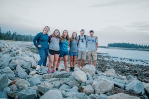
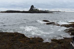
Following our second stay in Wells, we returned to Portland before catching the ferry for a week on Peaks Island in Casco Bay. Once on Peaks, we observed the changes in wave energy affecting the island around its perimeter. To the north, south, and west of the island, neighboring islands and the mainland mostly protect its shores from the open ocean. On the east side, however, distant swells are able to impact the island due to its large fetch. Fetch is the horizontal distance of ocean surface over which the wind blows and wind-driven waves are formed. The varying wave energy received by the shores of Peaks Island is evident in the distribution of sediments. On the protected west side, beaches are found with predominantly sand and other fine sediments. On the unprotected east side, powerful wave action results in much larger sediments, such as cobbles and even some boulders. The rest of the time spent on Peaks Island was filled with textbook reading and lectures to prepare us for the next ESS adventure: nine days aboard a schooner.

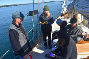
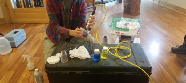
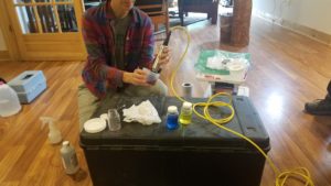
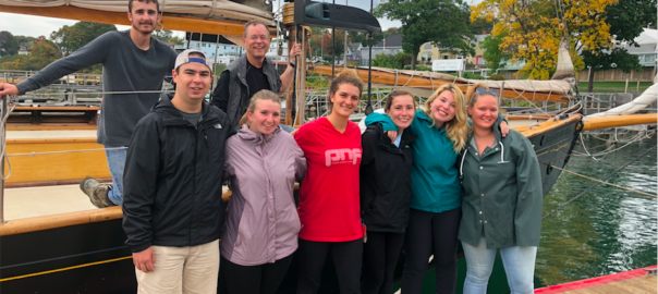
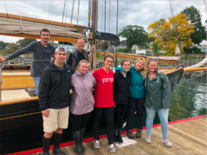
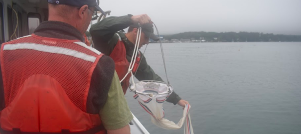
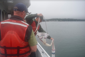
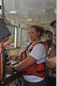
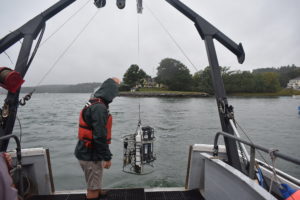
For the first day, we boarded the 94-year-old, 72′ schooner Bagheera (yes, named after the black panther in The Jungle Book) for a day sail around Casco Bay to learn how to operate the equipment to be used for the 80-nautical mile voyage to Port Clyde. For sampling the water column, we used a CTD sonde and Van Dorn bottle to determine salinity, temperature, dissolved oxygen, and pH at several depths. To analyze the sediments on the sea floor, we used a Ponar dredge or a coring device to bring samples up to the deck. At the end of the day, we returned to Peaks Island to pack and get some rest before setting sail.

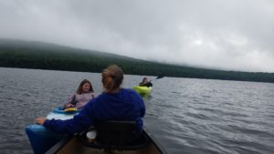
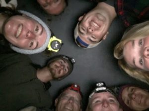
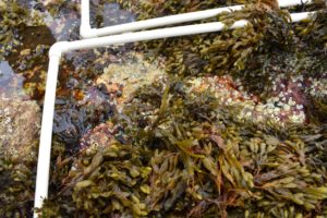
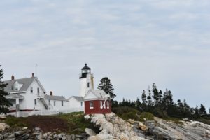
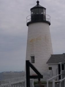
The next morning, we were up bright and early to load our gear onto Bagheera. We then disembarked for our first full day on the open water. After stopping to record a few samples, we arrived at Jewell Island for our first night. Jewell Island, inhabited by the U.S. military in both WWI and WWII, is home to an extremely large tide pool known as the Punchbowl. With a calm tide pool before us and the crashing open ocean beside us, we learned about the relationship between wave energy and sediment transport. We also learned about how waves refract as they encounter a headland, a cove, or shallow water near shore. After dark, Dr. Erikson lead us to one of the island’s artifacts of WWII: a German U-boat lookout tower. With headlamps on, we ascended the tower to the highest floor, where the city lights of Portland could be seen in the distance. The next morning, we continued our journey up the coast, learning along the way.

-Jarrett Beaulier

Zonation in the Salt Marsh

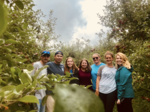
Before heading back to the Wells National Estuarine Research Reserve, the gang stopped at Thompson’s Orchard for some fall festivities – apple picking and donut eating.

In Wells, the salt marsh was another strong example of zonation that we’ve seen throughout our learning. They are formed by an accumulation of river sediment that builds up along the coast. Eventually, this turns into a vast land of peat (decomposed plant matter). As we approach the seaward side of the marsh, species of plants have to be more tolerant of high salt content, be able to survive flooding twice a day, and endure other stresses such as anoxic stress.

As we go further back into tree line, we noticed that species vary based on their ability to tolerate these stressors and compete with other species. Dr. Bernacki, a biology and ecology professor, was with us for this four day section. All of our professors have really encouraged us to observe and make suggestions on our own of what we think is happening around us. One thing that was unique to this section was that we were able to work in groups of three to form our own experimental designs and test them out to see if it supported our original hypothesis’. For me, being someone in the group who just started to take science courses this summer, it was really exciting to think about what I wanted to test and how I was going to achieve that.

One group designed an experiment to test if there was a gradient of species from one salt pan to another. The other group designed an experiment that tested the richness amongst species from high tide line to tree-line.

Since September 30th, we have been on Peaks Island where one of our professors actually lives (so we officially have a new member on board the ESS, Pirate)! With just a little over 2 weeks away from the finish line, we are coming to the realization that we are going to have to say goodbye soon. We have been cherishing all of our moments together. We have spent lots of late nights together writing papers, sharing stories, laughing, and just being family. We are now heading full speed into our new course, Oceanography. Stay tuned from more about our life on the island and our journey on the schooner!

Creatures and Waves at the Rocky Intertidal Zone

After our first adventure on a research boat studying the Damariscotta River estuary, where we observed how the salinity and mixing state of the estuary affects the diversity of zooplankton and phytoplankton population, we moved on to Rocky Intertidal Zones. We went to Ocean Point at Linekin Neck in Boothbay Harbor, Maine. We completed a transect of the intertidal zone using our previously developed method with a 50-yard tape measure and an inclinometer to determine the slope of the shoreline. The rocky face was covered with many different forms of life, and despite the slippery surface, we found the slopes of each leg of the transect to map the estimated zones of the intertidal.


Along the transect, specifically in two-meter intervals, we took flora and fauna surveys of the sessile and motile organisms within the different quardrats we measured. We used a 0.25 m2 quadrat to measure the percent coverage of sessile organisms and a 1 m2 to measure the motile organisms. We found that the physical stresses of the exposed rock, such as the wave shock and desiccation, greatly affect what organisms can live in the exposed area. We found mostly red algae, such as Condrus crispus, right at the low tide line, and many colonies of barnacles towards the middle of the intertidal zone, where there is less exposure, but still great variation of species throughout the tide cycle. From our observations, we concluded that both physical and biological stresses greatly affect the organisms that live in the intertidal zone

After a field day of exciting research, full of wonderment and awe (as Greg would say), we enjoyed a day at the Common Ground Fair. This fair was not your typical rides and games fair, but it was very fun, and they had very good food. After the fair we went out to dinner for Greg’s birthday at Shaw’s Fish and Lobster Rolls, where the view of the harbor at sunset was beautiful. We are all as happy as clams to continue on this trip!

Damariscotta Estuary

After an early morning wake up, we set off to experience the main attraction the Darling Marine Center had to offer, the Damariscotta River estuary. Heading down to the boat, it had already started off rough; rainy and cloudy, but it was all worth it in the end.

This estuary is unusual because most estuaries have a lot of freshwater flowing out into the ocean, but this one has much more seawater flowing into the river. Starting at the head of estuary at the town of Damariscotta, we cruised the length of the estuary, stopping at 6 spots, or stations, heading to the ocean. We pulled plankton nets to catch zooplankton and phytoplankton at each station. We also used a 200-pound instrument called a CTD which is used to measure the conductivity or salinity, temperature, and depth of seawater. Being the techie on the crew, I operated the computer of this fancy device.

Learning to control the winch as we swung the heavy CTD into the water took some time, but we got the hang of it after the second station. As we got to the higher energy wave swells towards the mouth of the river, we had to work quickly to avoid anyone danger or damage from the pitching instrument. Through our time on the boat, we saw seals, and even dancing lobstermen on a float. Some experienced seasickness, and we all got a taste of what life on a boat will be like when we get to the schooner.

A few days later, with some convincing, we went to the Common Ground Fair in Unity, Maine. For some of us it was the first time going, and it was different from the Fryeburg Fair; lots of organic food, people walking around barefoot, flowers and flower crowns. Everyone was smiling at you as you walked by. Being in a whole new setting, and seeing loved ones, caused this day trip to definitely be worth it!

Sense of Place in Midcoast Maine

Each time the ESS establishes a brief residence in the Midcoast region of Maine, on the Pemaquid peninsula, I bring the students to a local landmark for a study break to learn a bit of local history and gain a ‘sense of place’. Many books and PhD theses have been written about the history of this region. Indeed, the students will read scientific journal articles of seminal works of marine ecology research, at sites we visit on this very peninsula. A perennial favorite site to visit is the lighthouse at Pemaquid Point.

The simple, scenic lighthouse is one of the earliest and most famous of Maine’s lighthouses. It is the lighthouse featured on the Maine State quarter, by popular election of the people of this great state. The lighthouse’s understated beauty is perhaps upstaged by the fantastic rocky promontory upon which it is set. After a few weeks of geology to start the ESS, the students were quick to identify the metamorphic gneiss, with prominent intrusions of igneous quartz and plagioclase.

Most of the students climbed to the top of the lighthouse tower to see the ‘fourth order Fresnel lens’ that produces the light signal. They also visited the little museum with displays telling of the lighthouse and the surrounding region. They clambered over the rocks, and took note of the zonation of organisms on the rocky intertidal zone that will be the subject of their next study.

But the main purpose of the visit here was to open a window into a sense of place. I spent the summers of my youth, and two years obtaining my Master’s degree, here on the Pemaquid peninsula. My relationship with this place is as familiar and  nourishing as with a sibling. There is no hope of creating such a feeling in barely a week with students new to the location. Yet by intentionally encouraging them to incorporate all they observe and experience, through all the senses and via different perspectives, I hope they will look at locations not just as a study site with a narrow focus on the specific lesson, but develop a sense of place, a holistic feeling for the connections between the natural world, the history of human activity here, and their own experience in this space, this time. I hope they develop the capacity to feel the sense of wonderment and awe for this special place, and the special experience of the ESS. Cue the eye rolls, “there he goes again with the wonderment and awe…”

Waves of fun at Cape Cod!

After an adventurous week in Canada we all were eagerly awaiting the next phase of the trip, on the beaches of Cape Cod. Following a long day of driving we arrived in Orleans on Cape Cod the night of September 9th. As we transitioned into the next section of the semester, Marine Ecology, what better place to start than the beach! 
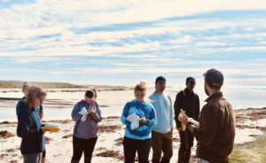
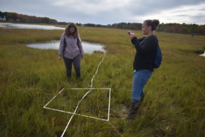
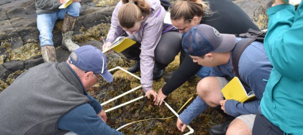
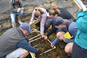
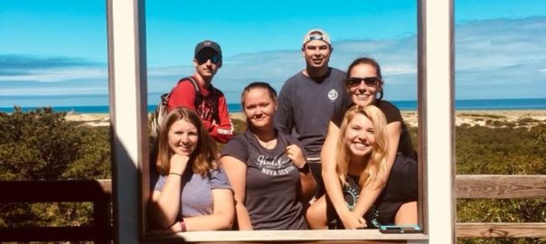
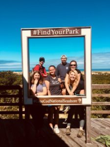
This past week was dedicated to making beach profiles, measuring sediment distributions, determining wave height and energy, all to establish the morphodynamic state of the beaches. We also surveyed the fauna found at high- and low-energy beaches. Although we were staying on the Massachusetts Bay side of Cape Cod, we compared the different energy levels and other morphometric features between the Bay and ocean side beaches of the Cape Cod National Seashore.

In order to conduct a beach profile, it is necessary to first observe. We noted obvious features such as the shape of the beach, traffic of people, and even birds. Then we went more in depth by measuring sections in which there was a change of slope. This allowed us to divide the beach into its component parts and note changes the in fauna from one part to another. The two beaches we observed were Skaket beach located on the Bay side and Nauset Light beach on the ocean side. We concluded that Skaket beach consisted of low energy system where fauna such as lady crabs, hermit crabs, razor clams, and various algae were present because it was a stable environment. Nauset Beach on the other hand had large waves and no obvious fauna suggesting a high energy environment.

When we weren’t making beach profiles we took advantage of staying right on the beach. We hung out in the sun, went swimming, and most importantly found time to relax. We even saw a few seals! Saturday, September 15 marked the day of our halfway point of the semester. It’s crazy to think of all that we’ve accomplished in 5 whole weeks! The next 10 days will be spent at the Darling Marine Center located in Walpole, Maine, where we will continue our studies on estuaries, rocky intertidal habitats, and mudflats.

Halifax to Cape Cod: 3 States, 2 Countries, 1 Day

     On Monday, September 3rd, we packed up our stuff, left the campground in Fundy National Park, and drove to Joggins Fossil Cliffs in Nova Scotia. Joggins is located on a beach with cliffs along the length of the back beach. We got to see a lot of rocks from the Carboniferous era. Some of the rocks and cliffs had fossils embedded in them. The most prominent fossils were of trees that are related to today’s club moss. We were able to determine that the trees were from a swampy area due to the reddish color (a tropical wet climate indicator) of the sediment surrounding the tree fossils. We also measured the length of the beach in segments, used a compass to find the dip angle of the cliffs along the beach, and then used trigonometry to find the thickness of the cliffs (430 meters) as if they had been stood upright instead of laying on their side.

     Once we finished measuring, observing, and looking for fossils in Joggins, we drove to Halifax, Nova Scotia for dinner and to check in at the hostel we stayed at. Most of our time in Halifax was spent wrapping up the Glacial Geology and Climate Change Class. We wrote a lab report comparing the climates of the Hopewell Rocks and Joggins, we wrote our final paper for glacial geology, and we took our final. We also did some exploring. Dr. Erikson took us to the Citadel Hill, an old fort and historic site. We walked around the fort and through the exhibits to learn about some of the history. We then walked around the outside of the fort for a scientific aspect. The Citadel is located on a drumlin, a glacial deposition landform that looks like a circular mound, created by a glacier retreating and depositing till.

     Lawrencetown beach was another place we visited while in Halifax. The first part of the beach we went to had an eroded drumlin along the back beach. The sediment in the drumlin was a grayish color on the bottom and red on top. We measured the trend of the rocks in the two colored sediments and saw that the glacier switched the direction it was moving while the drumlin was being formed. We then went to another, sandier, part of the beach to walk along the beach, in the water, and show off our cartwheel skills.

     When we weren’t doing homework, taking tests, or learning about glacial geology; we walked along the boardwalk in Halifax, went shopping, played games, watched movies, and visited the public garden. After four weeks of traveling and living together, we’ve transitioned from strangers/acquaintances to friends to family.

     Saturday, September 8th, was our last day in Halifax. We took our final Saturday morning, then drove to Kejimkujic National Park where we camped for the night. We spent the afternoon canoeing and kayaking, then had dinner, and spent the night star gazing. This morning we woke up early, and are making the long trip (two countries, two provinces, and three states) to Cape Cod to start our next class, Marine Ecology, with Greg!

-Caleb Gravel

Fundy National Park: The Tides Have Turned

After our time at Schoodic Point, we loaded up the van and trekked northward up the coast. We made several stops along the way to evaluate the relative and eustatic sea level changes of the region. Of these stops were Machiasport (for sea level change), Jacksonville (for an esker and isostatically-induced relative sea level change), and Quoddy Head, Maine; the easternmost point in the United States.  After a few photos, we continued our journey north to Calais where we crossed the international border into New Brunswick, Canada. From there, we pushed eastward into Saint John, NB to grab a bite to eat before arriving at our destination of Fundy National Park in the late evening.

The following morning, we ventured to the Caribou Plains area of the Park to assess modern climate. We were met by a tall, coniferous forest and a mossy forest floor. This region is considered the farthest southward extent of the boreal forest biome in North America. This biome is characterized by forests like the one before us; wet and mossy with predominantly coniferous timber. These observations are due to the biome’s wet conditions on the climatic scale. Boreal forests are classified as temperate rainforests. This can be attributed to the region’s latitudinal position.  
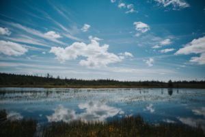
The extent of the boreal forest sits around the northern hemisphere’s subpolar low pressure zone; an area characterized by cloudy skies and lots of precipitation. Amongst the forest was a peat bog. Peat bogs are formed when layers of moss grow upon one another atop stagnant water. The constant moist and low-oxygen conditions prevent decay, allowing new moss to grow on top of old, dead moss, resulting in meters of layered peat. After some time in the forest, we returned to the campground to finish some homework.

A couple days later, we travelled to Hopewell Rocks to assess ancient climate. Hopewell Rocks gave us a glimpse at millions of years of sediment deposits from the Carboniferous Period (»350 million years ago), layered atop one another in the exposed cliff walls. The layers are not parallel to the ground since the earth there has risen in some places and fallen in others due to changes in isostasy (or buoyancy of the Earth’s crust). Using a little high school trigonometry, we were able to calculate the layers to be over 400 meters thick!  
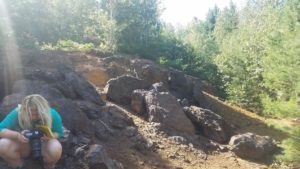
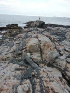
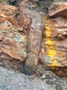
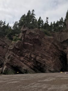
To evaluate the ancient climate, we had to look specifically at the sediments within the layers. The majority of the layers contained large river deposits, suggesting the area was characterized by exceptionally wet, and potentially tropical, conditions. We later learned that the region surrounding Hopewell Rocks was located in the tropical region of an ancient supercontinent around the time these deposits were made, confirming our hypotheses.

While in Fundy National Park, we were able to enjoy the beautiful Canadian wilderness, in addition to the widest tide range in the world – up to 54 feet! We also camped for the first time as a group, and I celebrated my 20th birthday with propane stove-cooked cake, courtesy of Dr. Erikson. The good times are rolling and so are we! Next stop: Halifax.

Click here to see 4 seconds of Jarrett’s birthday!


-Jarrett Beaulier


Acadia and Glacial Erosion

After Katahdin Iron Works, we traveled out towards the coast to Acadia National Park, where we stayed on the Schoodic Peninsula at the Schoodic Education and Research Center. Being on the shore, we were able to study the effects both of glacial erosion in the bedrock and of hundreds of meters of sea level change during and since the Pleistocene ice age. There were striations and chatter marks made by rocks embedded in the glaciers grinding across the bedrock. These allowed us to estimate the south-southeast direction of flow of the glacier. At Schoodic Point, we used the principle of cross-cutting relations to construct a relative dating history of a dozen events from granitic magma rising in the crust to basalt cooling to glacial melting to recent sea level rise and erosion.

We took a trip to Mount Desert Island, where we stopped at several places to study the glacial erosion. At Jordan Pond, we saw how the glacier moved over and around The Bubbles (two small mountains with a U-shaped valley in between), causing stoss and lee features on the up-glacier and down-glacier sides of the mountains. The stoss side had abrasion from the grinding glacier and the lee side had steep cliffs where plucking by the glaciers removed giant blocks of stone. The pond itself was formed through the repetitive retreating and advancing of the glacier. That day we also traveled to the top of Cadillac Mountain by van, where the views of Bar Harbor, as well as many of Maine’s islands could be seen.

That evening, we also ate dinner in Bar Harbor (or Bah Habah) and spent some time walking around and enjoying the sights. Because of the low tide at the time we were there, we got to walk out onto the sandbar that leads to Bar Island, which was very cool to walk across, and for skipping rocks too!

The next day, after a midterm exam (yes! a midterm!) we went swimming on Schoodic Peninsula. It was so cold! But the Bay of Fundy, where we are headed next, is going to be even colder! Its very cool to experience each aspect of what we are learning where we are, and I’m excited to find out what we’re learning about next!

Katahdin Iron Works & Testing for Acid Mine Drainage

Before the actual chemistry started, Dr. Emily Lesher showed the ESS group how to properly use the pH and conductivity probe out in the field. After one long day of sediment and water sample collection on Ore Mountain near Katahdin Iron Works east of Greenville and Moosehead Lake, we were all able to determine the concentration of iron in the water samples, and the pH and conductivity for both. It’s called Ore Mountain because of the different metals found within it, such as iron, cobalt, nickel, copper, and silver; it was mined from 1843 to 1890. Now, this mountain is the largest cobalt reserve in the country. Cobalt is known for its beautiful blue color, but it’s also a toxic metal used in cancer treatment and batteries.

Through a series of chemical steps, we were able to analyze the iron concentration of the water samples that the toxic metals had flowed into. A large part of the mountain’s rocks are iron sulfides with trace amounts of cobalt.  Once the iron sulfide reacts with water and oxygen, it produces sulfuric acid, which together with the cobalt, iron, nickel, copper, and silver flows into the streams as something called acid mine drainage. Testing the samples, the pH samples varied from 2.6 (which is nearly the pH of vinegar) to 6.56 (nearly at a neutral pH of 7). It seems that the whole mountain was tainted with iron and vegetation was dead from the many years of mining and exposure to the acid and metals.

Being at Katahdin Iron Works for three days, not every day is full of experiments and extensive thinking, we also have downtime for swimming, canoeing, ping pong, playing card games or just napping! Staying up until midnight by a campfire, laughing and talking. Staying at the dinner table, talking about our day and making jokes.