After our time at Schoodic Point, we loaded up the van and trekked northward up the coast. We made several stops along the way to evaluate the relative and eustatic sea level changes of the region. Of these stops were Machiasport (for sea level change), Jacksonville (for an esker and isostatically-induced relative sea level change), and Quoddy Head, Maine; the easternmost point in the United States.  After a few photos, we continued our journey north to Calais where we crossed the international border into New Brunswick, Canada. From there, we pushed eastward into Saint John, NB to grab a bite to eat before arriving at our destination of Fundy National Park in the late evening.
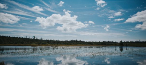
The following morning, we ventured to the Caribou Plains area of the Park to assess modern climate. We were met by a tall, coniferous forest and a mossy forest floor. This region is considered the farthest southward extent of the boreal forest biome in North America. This biome is characterized by forests like the one before us; wet and mossy with predominantly coniferous timber. These observations are due to the biome’s wet conditions on the climatic scale. Boreal forests are classified as temperate rainforests. This can be attributed to the region’s latitudinal position. 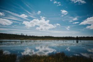 The extent of the boreal forest sits around the northern hemisphere’s subpolar low pressure zone; an area characterized by cloudy skies and lots of precipitation. Amongst the forest was a peat bog. Peat bogs are formed when layers of moss grow upon one another atop stagnant water. The constant moist and low-oxygen conditions prevent decay, allowing new moss to grow on top of old, dead moss, resulting in meters of layered peat. After some time in the forest, we returned to the campground to finish some homework.
A couple days later, we travelled to Hopewell Rocks to assess ancient climate. Hopewell Rocks gave us a glimpse at millions of years of sediment deposits from the Carboniferous Period (»350 million years ago), layered atop one another in the exposed cliff walls. The layers are not parallel to the ground since the earth there has risen in some places and fallen in others due to changes in isostasy (or buoyancy of the Earth’s crust). Using a little high school trigonometry, we were able to calculate the layers to be over 400 meters thick! 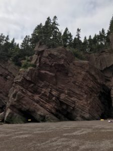 To evaluate the ancient climate, we had to look specifically at the sediments within the layers. The majority of the layers contained large river deposits, suggesting the area was characterized by exceptionally wet, and potentially tropical, conditions. We later learned that the region surrounding Hopewell Rocks was located in the tropical region of an ancient supercontinent around the time these deposits were made, confirming our hypotheses.
While in Fundy National Park, we were able to enjoy the beautiful Canadian wilderness, in addition to the widest tide range in the world – up to 54 feet! We also camped for the first time as a group, and I celebrated my 20th birthday with propane stove-cooked cake, courtesy of Dr. Erikson. The good times are rolling and so are we! Next stop: Halifax.
Click here to see 4 seconds of Jarrett’s birthday!
-Jarrett Beaulier

